

{{product.productLabel}} {{product.model}}
{{#if product.featureValues}}{{product.productPrice.formattedPrice}} {{#if product.productPrice.priceType === "PRICE_RANGE" }} - {{product.productPrice.formattedPriceMax}} {{/if}}
{{#each product.specData:i}}
{{name}}: {{value}}
{{#i!=(product.specData.length-1)}}
{{/end}}
{{/each}}
{{{product.idpText}}}

The Leica BLK2FLY is an autonomous flying laser scanner with advanced obstacle avoidance for easy reality capture from the sky. It captures building exteriors, structures, and environments to create 3D point clouds while ...
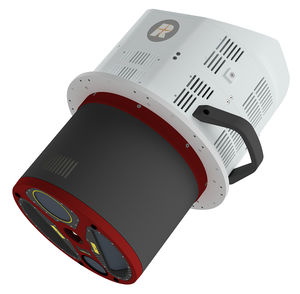
Measuring distance: 1,600 m
... 3,900 m AGL at a pulse repetition rate of 560 kHz (all values given for 20% target reflectance). A high-performance IMU/GNSS unit and one or two optional high resolution RGB/NIR cameras are seamlessly integrated in ...

RIEGL‘s latest generation of professional Terrestrial Laser Scanners stands out with extreme versatility, high productivity, ultimate performance and additional mobility – providing an excellent return on investment! The ...

RIEGL VZ-6000 This 3D VZ-Line Laser Scanner offers superior and unrivaled long range reflectorless measurement performance of more than 6,000 m. RIEGL ́s unique V-Line technology is based on echo digitiza-tion and ...

Length: 382 mm
Width: 228 mm
Measuring distance: 0.5 m - 50 m
The Q1 Laser RADAR is a 3D optical metrology tool for precise measurement. It is designed for simplicity and cost-efficiency. With 128 parallel channels, it offers high accuracy and fast, non-contact data collection. It suits various ...

Length: 905, 1,550 mm
Measuring distance: 0 m - 2,000 m
MS series 3D Mapping LiDAR scanners are TOF LiDARs that designed for achieving 3D detection and imaging, accurately obtaining the surrounding environment information. With various maximum detection distances from 150m ...

... able to overcome the challenges of surveying in areas with poor or no GNSS signals, bringing a new level of flexibility and accuracy to their work. By supporting both traditional GNSS RTK surveying and ...

Measuring distance: 0 m - 120 m
The LS300 Laser Scanner uses SLAM technology (simultaneous localization and mapping), which is real-time positioning and mapping technology. It does not rely on GNSS positioning, and performs self positioning ...
the best suppliers
Please specify:
Help us improve:
remaining