
Rely on this advanced P4 software debug tool to more easily optimize software written in the P4 programming language. Speed Up Software Development for the Data Plane Reduce your ...
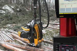
SYSTEMS FOR TRACK-BASED FOREST MACHINES N/A Address Ponssentie 22, Vieremä, 74200 View on map Phone 020 768 800 Services Sales, Factory, Training SYSTEMS FOR TRACK-BASED FOREST MACHINES OVERVIEW Making a track-based machine ...

... surfaces, planes, cylinder, and cylinder center lines. Descartes lets you create high-fidelity images to support precision mapping and engineering, and you can process raster images to add visualization and context to ...
Bentley Systems Europe B.V.
Powerful historian software for operations data collection, on-prem or cloud storage, and analysis Manage your industrial time series and A&E data with scalable historian software Proficy Historian ...
General Electric

MWVirtualCom is a virtual serial port management software specially designed for serial port Ethernet servers. On the Windows system, the MwVirtualCom application program can virtual COM port, mapping ...
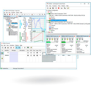
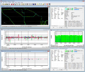
The canAnalyser is a versatile tool for the development, testing and servicing of CAN, CAN FD and LIN based systems. The software package is based on a modular concept and available in three versions (mini, lite and standard) ...
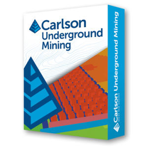
... produce accurate, customized reports with Carlson Software’s renowned ease of use. Mine plans can be quickly modified to compare alternatives, thereby ensuring the most efficient design. UNDERGROUND MINE MAPPING • ...
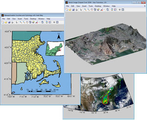
Mapping Toolbox™ provides algorithms and functions for transforming geographic data and creating map displays. You can visualize your data in a geographic context, build map displays from more than 60 map projections, ...
... even when lower grade inertial sensors are used. IE can produce results suitable for demanding applications such as mobile mapping, aerial and hydrographic surveying. IMU data from high end Fibre Optic Gyro (FOG) or Ring ...
... Visual SLAM: Our Visual SLAM algorithm leverages cutting-edge vision techniques to provide robust, precise navigation and mapping in dynamic environments. This enhances operational efficiency and scalability without the ...
Make informed strategic decisions about your supply chain based on detailed analyses using large amounts of data with W2MO Supply Chain Engineering. Gain agility, speed and efficiency through strategic planning Easy to use and ...
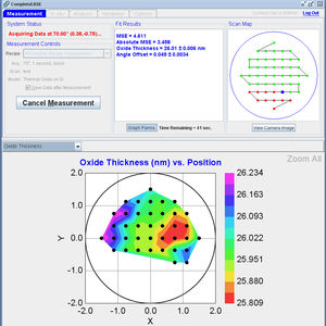
The next generation of ellipsometry software has arrived with CompleteEASE®, our revolutionary new software for Woollam ellipsometers. It’s easier than ever to use, and with the world-class quality you’ve ...
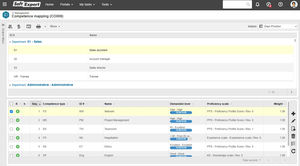
Effectively manage all of your company's competencies through mapping, development, monitoring, and evaluation of each team member. Track progress on established actions and performance evolution, gaining a holistic and ...
SoftExpert
... GNSS module to add precise coordinates to images. This workflow is for drone pilots who have Reach M2/M+ on a drone for PPK mapping. Kinematic processing Get precise track of measurements using raw data from the base ...

... of land surveying and road engineering projects in the field. Combining with the international mainstream of surveying and mapping data acquisition function, it integrates with professional receiver control, point collection, ...

... referring to predefined ground control points (GCP’s) Z+F SynCaT® is a modular structured mobile mapping software. The modularization allows to combine the software package specifically ...

... urban environments alike. MIPAR software can accelerate the critical analysis of complex visual imagery and provide fully automated characterizations of specific regions of interest. For example: Our drone imaging software ...
... reporting software tool that is part of our RetroTek measurement system. It provides the capability of processing and viewing the results from a single survey run on your PC or laptop screen. This includes an interactive ...

... . How it works A Waylay ‘digital twin’ is an asset record under a Salesforce parent asset and contains a configurable mapping of an IoT device and its IIoT data. Business users with access to the Salesforce parent ...
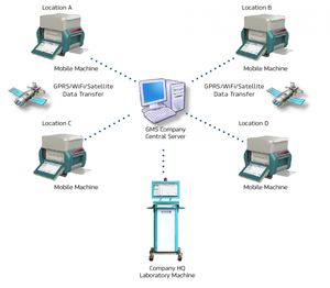
... Xenemetrix Geological Mapping Solution (GMS) include compact size 50W tube power mobile analyzers that can easily be transported between sites, or robust bench-top systems stabile for installation in mobile laboratory. ...
Condor – 3D GPR Processing & Interpretation Software Condor is modern processing, visualisation and interpretation software for the efficient management of Raptor 3D GPR array data. Boost performance ...
ImpulseRadar

Photogrammetry Processing Software Framework The state-of-the-art photogrammetry & computer vision algorithms integrated into the software enables users to automatically reconstruct geometric structures ...
GreenValley International
... integrated code generator Web-based tool Management of all fieldbus-based data from specification to release Development, mapping and maintenance of the communication interfaces of ECUs Description of the entire ...
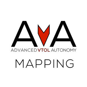
... with a focus on mapping missions. AvA controls the FireFLY6 through all flight regimes: hover, forward flight, and transition. The AvA Mapping Key is the best choice for those who are looking to apply ...
... and Microstation® or synchronizes ETAP with other applications such as Intergraph SmartPlant® Electrical. Customizable data mapping, intelligent error checking, and automated one-line diagram generator are amongst the ...
the best suppliers
Please specify:
Help us improve:
remaining