

{{product.productLabel}} {{product.model}}
{{#if product.featureValues}}{{product.productPrice.formattedPrice}} {{#if product.productPrice.priceType === "PRICE_RANGE" }} - {{product.productPrice.formattedPriceMax}} {{/if}}
{{#each product.specData:i}}
{{name}}: {{value}}
{{#i!=(product.specData.length-1)}}
{{/end}}
{{/each}}
{{{product.idpText}}}

Measuring distance: 0 m - 120 m
Lixel X1 real scene 3D reconstruction scanner – a compact, powerful, and precise LiDAR scanner for capturing real-world scenes and generating detailed 3D models instantly without post-processing. Powered ...

Length: 227 mm
Width: 98 mm
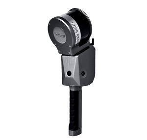
Measuring distance: 105 m
... the Cygnus Handheld LiDAR Scanner supports and assists you in 3D point cloud data acquisition efficiency to the fullest. No need to rely on GNSS satellites, Cygnus can help to obtain data in any outdoor, indoor, underground ...
Measuring distance: 4,600 mm
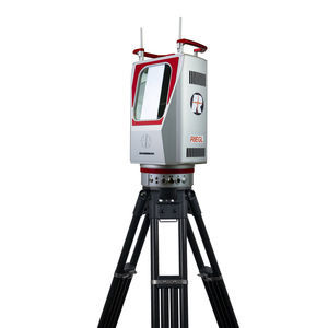
With the VZ-4000i25 RIEGL now present the long-range version scanner of their latest generation of professional terrestrial laser scanners. It stands for an increase in productivity, reliability in performance, ...
RIEGL LMS

Measuring distance: 720 m
... and versatile airborne laser scanner offering a wide field of view of 100 degrees and an extre-mely high pulse repetition rate of up to 2.4 MHz. Thus, it is perfectly suited for high point density corridor mapping applications. The ...
RIEGL LMS

... data and image data. A full documentation of the scanner‘s software components – directly accessible on the RIEGL VZ-2000i – provides a sound basis for creation of your own python apps to enhance the scanner ...
RIEGL LMS

Length: 281 mm
Width: 283 mm
Measuring distance: 300 mm
... and Dynamic Tracking without Markers Accuracy up to 0.023 mm (0.0009 in) High-speed scanning up to 3,070,000 points/s Large tracking range FreeProbe (optional) is available Optical 3D Measuring and Dynamic Tracking ...
SHINING 3D

Length: 331 mm
Width: 120 mm
Measuring distance: 200 mm - 300 mm
... The Power of Three 5MP Cameras With three industrial cameras, each wielding 5MP, the FreeScan Trio brings out the most elaborate details and high-quality 3D data. Unrelenting Accuracy and Precision Under ...
SHINING 3D

Length: 193 mm
Width: 63 mm
Measuring distance: 200 mm - 300 mm
... combination of blue laser and infrared light sources meets the needs of diverse industrial 3D scanning scenarios. Multiple Scanning Modes Up to 25 cross laser lines to scan large objects quickly, ...
SHINING 3D

... SisuROCK workstation is a groundbreaking tool for increasing accuracy and productivity for geological research applications and the mining industry.

Width: 217 mm
Measuring distance: 2 m
... tripod, vehicle, or moving platform, the outstanding performance of the Polaris makes it the most versatile terrestrial laser scanner on the market. Owners can select from three possible range modes to get a system that ...
Optech

FARO Orbis is the all-in-one mobile laser scanner with integrated stationary scanning, powered by FARO FLASH technology™. FARO® Orbis™ is a unique mobile scanning solution created ...
... Map inaccessible underground areas to ensure operations keep employees safe. C-ALS SUPPORTS SUCCESSFUL PROJECTS C-ALS gives you new underground mapping capabilities. You can safely, quickly and reliably ...
Carlson Software

Length: 382 mm
Width: 228 mm
Measuring distance: 0.5 m - 50 m
... high accuracy and fast, non-contact data collection. It suits various industrial and field applications. The Q1 handles long-range measurements up to 50 meters. It is ideal for large ...

The Trakblaze TVS (Mining Truck Volume Scanner) is a non-contact mining dump truck volumetric scanning system to measure loads of bulk loose solids. The TVS system scans volumetric loads ...
Trakblaze Pty Ltd
Measuring distance: 40 cm - 7,900 cm
Based on the high quality laser scanner Z+F IMAGER®, Zoller + Fröhlich GmbH and DMT GmbH & Co. KG have developed an explosion proof 3D laser scanner. The Z+F IMAGER® 5006EX pioneers surveying in underground ...

... engineering, and BIM professionals, as well as for applications such as agricultural and forestry surveying, power line inspection, material pile volume calculation, and data collection in underground ...

Length: 262 mm
Width: 142 mm
... and immersive panoramic imagery tailored for various applications, including road surfaces, highway maintenance, and asset management through vehicle-based surveying. The AU20 is redefining mobile ...

Length: 32 cm
Width: 21 cm
AlphaUni 900/1300, belonging to our Alpha Mobile Mapping series, are high-end multi-platform LiDAR systems that have been designed and improved by CHCNAV based on many years of research and data capture experience. AlphaUni ...

... directly on-site or within a laboratory setting thanks to the different modular configuration options readily available. Three options of modular systems are offered: Compact, U-Shape and Container to accommodate all ...
the best suppliers
Please specify:
Help us improve:
remaining