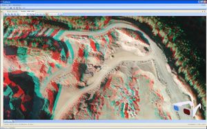
Surveying software Tcp PointCloud Editorgeographical data managementmodelingediting

Add to favorites
Compare this product
Characteristics
- Function
- geographical data management, modeling, editing, mapping, digital filter
- Applications
- construction, infrastructure, scanner, surveying, for civil engineering, for UAVs, construction project
- Type
- 3D
- Operating system
- Windows
- Deployment mode
- cloud
Description
Standalone application that allows to display, edit and analyze clouds of millions of points captured by fixed or mobile scanners, LiDAR technology or generated by photogrammetry applications.
Point clouds can be imported in the most common formats on the market. Points can have attributes of color, intensity, time, and category, and be represented based on these properties. You can apply offsets, rotations, or transformations to clouds, as well as register them using control points.
You can also generate and analyze surfaces and grids, calculate profiles and volumes, draw with a simple CAD on the point cloud, etc. It offers multiple options for importing and exporting formats such as LandXML, IFC, DWG, 3D PDF, etc.
You can import point clouds in the most common formats on the
market. Points can have attributes of color, intensity, time, and
category, and be represented based on these properties. You can
apply displacements, rotations, or transformations to clouds, as
well as register them using control points.
Filtering and editing
The application has tools for graphical selection of points by
window, polyline, sphere... Selection by attributes such as color,
intensity or category, make it possible to select a point and
delete those that have similar properties. Geometric selection
allows you to filter points by density, insulation, model, etc. The
terrain filter helps determine the points that belong to the
terrain.
The editing commands are applied to the selections of points,
being able to delete, change in category, hide, extract them to
a separate window, etc.
VIDEO
Catalogs
Tcp PointCloud Editor
2 Pages
Related Searches
- Automation software solution
- Management software solution
- Analysis software solution
- Windows software solution
- Computer-aided design software
- Control software solution
- Online software
- Design software solution
- 3D software solution
- Interface software
- Measurement software
- Simulation software
- Visualization software solution
- EDM software
- 2D software
- Creation software
- Reporting software solution
- Modeling software
- Planning software
- Calculation software
*Prices are pre-tax. They exclude delivery charges and customs duties and do not include additional charges for installation or activation options. Prices are indicative only and may vary by country, with changes to the cost of raw materials and exchange rates.


