Control software TcpETsurveyingfor civil engineeringWindows

Add to favorites
Compare this product
Characteristics
- Function
- control
- Applications
- surveying, for civil engineering
- Operating system
- Windows
- Other characteristics
- Bluetooth
Description
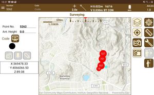
This field software, installed in the total station itself or in a data collector with Windows operating system, allows the user to survey and set out with a wide range of conventional, motorized or robotic stations, connected through serial cable or Bluetooth.
The program has options for all kinds of surveys and stake out (roads, railways, power lines, pipes, etc.). Orthoimages, DXF files or web map services can be used as a base map.
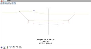
You can add to the project horizontal and vertical alignments, profiles, cross sections and superelevations. TcpET has options for staking out by station and displacement, station and code, slope control, and many more.
This application, installed in a pocket PC, allows the user to survey and stake out topographical data using a wide range of total stations, connected through a standard cable or through wireless Bluetooth technology. In motorised stations, the software will automatically direct the device to the desired location. The program provides numerous options and may be used for traditional mapping or surveying, and for projects involving linear works.
VIDEO
Catalogs
No catalogs are available for this product.
See all of Aplitop‘s catalogsRelated Searches
- Automation software solution
- Management software solution
- Analysis software solution
- Windows software solution
- Computer-aided design software
- Control software solution
- Online software
- Design software solution
- 3D software solution
- Measurement software
- Interface software
- Simulation software
- Visualization software solution
- EDM software
- 2D software
- Creation software
- Reporting software solution
- Modeling software
- Planning software
- Calculation software
*Prices are pre-tax. They exclude delivery charges and customs duties and do not include additional charges for installation or activation options. Prices are indicative only and may vary by country, with changes to the cost of raw materials and exchange rates.


