- Robotics - Automation - Industrial IT
- Automation
- UHF receiver
- ComNav Technology Ltd.
- Company
- Products
- Catalogs
- News & Trends
- Exhibitions
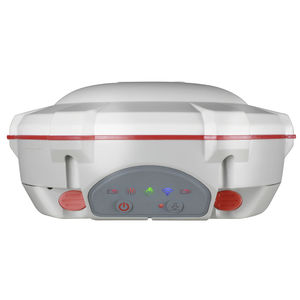
RTK receiver MarswirelessWCDMABluetooth

Add to favorites
Compare this product
Characteristics
- Type
- UHF, GNSS, RTK, wireless, satellite, Bluetooth, multi-constellation, multi-frequency, GSM, IP, WCDMA
- Applications
- for surveying, tracking, for construction site, harsh environment, reference station, for mining, for UAVs, for wireless data transmitters, data transmission, for robotics
- Interface type
- USB, serial, internet
- Other characteristics
- 1590 channels, compact, rugged, with integrated antenna, portable, IP67, high precision, laser, multi-frequency, full-constellation, low-latency, NFC
Description
The Mars Laser RTK is an innovative GNSS receiver that integrates the most advanced GNSS, IMU, and laser technologies. It combines GNSS receiver and laser technology, shattering usual constraints in land survey, construction, and GIS applications. It ensures precision and minimizes user fatigue, crafting an impressive surveying experience. With this state-of-the-art RTK module, Mars Laser RTK will perform at its highest levels, making it the best choice for surveyors.
1590 channels and 60+ satellites tracking capabilities
Tracking all running and planned constellations, including GPS, BDS-2, BDS-3, GLONASS, Galileo, QZSS, IRNSS, and SBAS
Up to 120° tilt with 2.5 cm accuracy
IP67 dust- and waterproof for harsh environments
20+ hrs non-stop use
Laser Technology
Mars’ precise green laser, visible in the daylight, allows to measure points where it’s impossible to stand with a range pole. The combination of the GNSS receiver and laser distance meter, fits ideally well with surveyors’ work and increase significantly the productivity.
IMU
Mars boasts a 3rd generation built-in IMU sensor that detects minute accelerations from the laser point or range pole. Using advanced algorithms, it can maintain high precision with tilt compensation up to 120° in laser mode, simplifying field surveying and eliminating manual initialization
New K8 Platform
Featuring 1590 channels and the ability to track more than 60 satellites, Mars is not just versatile, but also efficient by supporting SBAS PPP services. With its capability to achieve fixation within seconds, it significantly enhances productivity
VIDEO
Catalogs
Mars Laser RTK
2 Pages
Mars Pro Laser RTK
2 Pages
Related Searches
- HMI with touch screen
- RF antenna
- Outdoor antenna
- ComNav GNSS antenna
- ComNav IP67 antenna
- WLAN antenna
- ComNav GPS antenna
- External antenna
- ComNav radio receiver
- ComNav GNSS receiver
- Compact antenna
- Mobile antenna
- WiFi antenna
- Rugged antenna
- Industrial modem
- Measurement antenna
- Wireless operator terminal
- ComNav compact receiver
- Vehicle antenna
- Antenna for IoT applications
*Prices are pre-tax. They exclude delivery charges and customs duties and do not include additional charges for installation or activation options. Prices are indicative only and may vary by country, with changes to the cost of raw materials and exchange rates.


