
- Products
- Catalogs
- News & Trends
- Exhibitions
Project management software FLOW 360data collectionfile import/exportdata export
Add to favorites
Compare this product
Characteristics
- Function
- data export, synchronization, data collection, project management, file import/export
- Applications
- surveying
Description
Access your data anytime
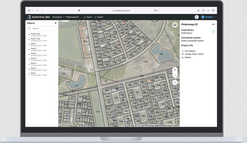
Make your projects available in any web browser
You no longer need a direct connection to a receiver or to Emlid Flow to export projects. Everything is now synced as soon as your smartphone has internet access. Just log in to Emlid Flow 360 with your Emlid account.
Create and manage code libraries
Work with survey codes
Link the codes library to quickly switch between different objects in the field. You can also add new codes to adjust the library for a specific project. And with your Emlid Account, this will be auto synced between all your devices.
Add WMS/WMTS layers
Make the full context visible
Elevate your survey workflow with WMS/WMTS layers. Gain access to up-to-date and accurate geospatial data like topographical maps, orthomosaics, composite satellite imagery, and more.
Inverse & Traverse
Adjust designs for the field
You no longer need 3rd party software to convert survey plans into real field projects. The Traverse tool allows you to create new geometry directly in Emlid Flow 360 at a given distance and direction from reference points. Inverse tool lets you calculate coordinate geometry attributes such as area, distance, direction, slope, and more.
Catalogs
No catalogs are available for this product.
See all of EMLID‘s catalogsExhibitions
Meet this supplier at the following exhibition(s):

Related Searches
- Automation software solution
- Process software solution
- Control software solution
- Real-time software solution
- EDM software
- PLC software
- Product lifecycle management software
- App
- Mapping software
- Surveying software
- Data export software
- Synchronization software
- Online mobile app
- Project management software
- Control App
- Data collection mobile app
*Prices are pre-tax. They exclude delivery charges and customs duties and do not include additional charges for installation or activation options. Prices are indicative only and may vary by country, with changes to the cost of raw materials and exchange rates.


