
- Products
- Catalogs
- News & Trends
- Exhibitions
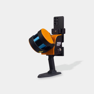
3D scanner GeoSLAM undergroundfor mappinglaser


Add to favorites
Compare this product
Characteristics
- Number of axes
- 3D
- Applications
- for mapping, underground
- Technology
- laser
- Configuration
- hand-held, mobile
Description
Mobile 3D data capture for mapping and understanding hard to reach spaces.
From the natural world to human-built environments, GeoSLAM technology delivers the power to collect geospatial data on the go. What sets GeoSLAM’s handheld mobile scanners apart is the user’s ability to reach and collect data from some of the world’s most difficult places, whether they’re indoors, outdoors, underground — everywhere.
Business Value of GeoSLAM
Mobile Mapping
Versatile 3D mapping laser technology is adaptable to any environment in all industries, and is especially well suited to complex and enclosed spaces.
Rapid Scanning
Within minutes you can collect data with a handheld scanner and later map a multi-story building in minutes with the accompanying software.
Save Your Business Time and Money
Fast data capture and modelling lets your teams successfully complete projects in minimum time with little disruption at the project site.
Tools for a Data Driven World
GeoSLAM digitizes 3D data capture, making it faster and easier to scan places that would have been impossible to scan before.
Catalogs
Orbis™ Mobile Scanner
8 Pages
Exhibitions
Meet this supplier at the following exhibition(s):

Related Searches
- Laser scanning system
- Measurement scanning system
- 3D scanning system
- Inspection scanning system
- Compact scanning system
- Portable scanning system
- LIDAR scanning system
- Fully integrated scanner
- Mobile scanning system
- Hand-held scanner
- 3D measuring arm
- Automated scanning system
- Color scanner
- Fixed scanning system
- Mapping scanning system
- Portable 3D measuring arm
- Scanner for mining applications
- 3D laser projector
- OEM scanner
- Cost-effective scanner
*Prices are pre-tax. They exclude delivery charges and customs duties and do not include additional charges for installation or activation options. Prices are indicative only and may vary by country, with changes to the cost of raw materials and exchange rates.


