- Robotics - Automation - Industrial IT
- Industrial Software
- Calibration software
- GreenValley International
Calibration software LiMappereditingmappingsurveying

Add to favorites
Compare this product
Characteristics
- Function
- calibration, editing, mapping
- Applications
- surveying
- Deployment mode
- cloud
Description
Photogrammetry Processing Software
Framework
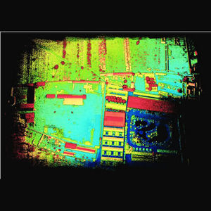
The state-of-the-art photogrammetry & computer vision algorithms integrated into the software enables users to automatically reconstruct geometric structures by overlapping aerial photos or multispectral images. LiMapper can generate a series of industry-standard photogrammetry products such as dense cloud, DEM/DSM & TDOM (true orthomosaic). Furthermore, functions such as bundle block adjustment, camera self-calibration & stitch line editing are also provided for improving workflow productivity & accuracy.
Advantages
Multi-Source Images Supported
High-Speed Processing
Streamlined Workflow In 3 Steps
Surveying Accuracy - Import Ground Points
VIDEO
Catalogs
No catalogs are available for this product.
See all of GreenValley International‘s catalogsRelated Searches
- Management software solution
- Analysis software solution
- Process software solution
- Real-time software solution
- Online software
- 3D software solution
- Measurement software
- Quality software
- Visualization software solution
- Automated software
- EDM software
- 2D software
- Reporting software solution
- Data management software solution
- CAM software
- Inspection software
- Construction software
- Product lifecycle management software
- Editing software
- Infrastructure software
*Prices are pre-tax. They exclude delivery charges and customs duties and do not include additional charges for installation or activation options. Prices are indicative only and may vary by country, with changes to the cost of raw materials and exchange rates.


