
- Products
- Catalogs
- News & Trends
- Exhibitions
Mapping software uViewerpositioning3D2D

Add to favorites
Compare this product
Characteristics
- Function
- mapping, positioning
- Type
- 3D, 2D
Description
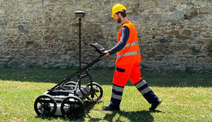
The uViewer application offers smart, user-friendly utility detection software to visualise GPR underground detected utilities in 2D, 3D, and Augmented Reality.
uViewer can import detected targets from Ground Penetrating Radars (GPR) as well as non-GPR technologies (i.e. cable locators) and highly enhances data visualisation to take utility detection and mapping to the next level. The uViewer software is designed to operate on site with any GNSS positioning systems as well as maximise user experience and
intuitiveness through smart devices (i.e. phones and tablets). In particular, the application leverages:
Visualisation of underground detected objects in 2D and 3D;
Visualisation of underground detected objects in Augmented Reality – with overlapping soil images recorded by smart device built-in camera;
Pipe Finder functionality – Software guides users in the field to pinpoint the exact position of a previously detected target (including distance, direction, and depth);
Digital cartographic map with coordinates and updated information on targets.
Catalogs

uViewer
2 Pages
Exhibitions
Meet this supplier at the following exhibition(s):

Other IDS GeoRadar products
Ground Penetrating Radar


Related Searches
- Management software solution
- Analysis software solution
- Process software solution
- Real-time software solution
- Online software
- 3D software solution
- Monitoring software solution
- Interface software
- Visualization software solution
- Network software solution
- EDM software
- 2D software
- Planning software solution
- Safety software
- Data management software solution
- CAM software
- Tracking software solution
- Inspection software
- Data analysis software solution
- Training software
*Prices are pre-tax. They exclude delivery charges and customs duties and do not include additional charges for installation or activation options. Prices are indicative only and may vary by country, with changes to the cost of raw materials and exchange rates.