
- Products
- Catalogs
- News & Trends
- Exhibitions
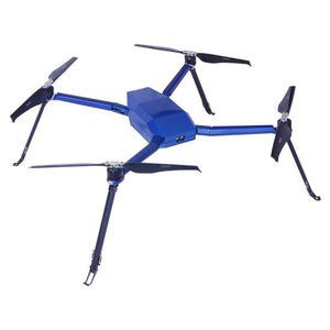
Mapping drone T60for industrial applications

Add to favorites
Compare this product
Characteristics
- Applications
- mapping, for industrial applications
- Endurance
Max.: 58 min
Min.: 0 min
- Payload
Max.: 4.5 kg
(9.921 lb)Min.: 0 kg
(0 lb)
Description
T60 rescue drone is composed of aircraft, ground station, payloads, remote control and accessories. The ground station broadcasts live rescue status to give rescuers decisions; remote controller extends the range to achieve 10km ultra-long-distance rescue. Through the use of the drone, it speeds up and improves the maritime rescue process, and makes smart & leading rescue service for the world.
T60 military grade quality, capable of working at any harsh environment
Built-in temperature measuring module, the drone will automatically return to home if the temperature is too high
High payload ability, can carry multiple payloads max weight up to 4.5kg
Geological Mapping
Drones can be used in aerial geological mapping data detection, transmitting a fully 360° 3D coordinates and distance in real-time.accompanied with the calibration of reflectance measurement. Drones can provide accurate, rapid and comprehensive geological data according to the required geological measurements in agriculture, electric power, geological mapping, etc..
VIDEO
Related Searches
- Digital camera module
- Visible camera system
- Infrared imager
- Surveillance camera
- Waterproof camera system
- Thermal camera
- High-definition camera
- Inspection camera system
- IR camera system
- Zoom camera module
- 4K camera
- Security camera module
- Camera with screen
- HDMI video camera
- Camera system with LCD screen
- IP54 imager
- Robotic camera system
- Camera for airborne applications
- UAV camera system
- Mapping drone
*Prices are pre-tax. They exclude delivery charges and customs duties and do not include additional charges for installation or activation options. Prices are indicative only and may vary by country, with changes to the cost of raw materials and exchange rates.

