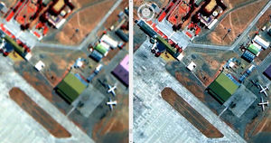
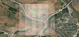
Do you work in an industry where you use massive, high-resolution images or point clouds? GeoCompressor lets you compress massive imagery or point clouds into much smaller files that are visually lossless, meaning that you cannot tell they are compressed by looking at them.
Using GeoCompressor, you can:
Compress terapixel-sized imagery or point cloud files with billions of points
Compress thousands of image files into a single mosaic
Update a region within an existing mosaic instead of having to recreate the mosaic every time a region in it changes
Clip to a polygon boundary to add the flexibility to create output products in accordance with arbitrary polygon definitions
Image compression
GeoCompressor allows you to input over 100 supported file types and output compressed Enhanced Compression Wavelet (ECW) and JPEG2000 (JP2) files.
Point cloud compression
GeoCompressor compresses LAS/LAZ files to Hexagon Point Cloud (HPC) files. HPC format is significantly faster and more detailed than existing storage formats.
Unprecedented performance
Throughput in excess of 180 MB/sec on commodity hardware and terapixel output images, make GeoCompressor the most high-performance mosaicking and compression tool on the market regardless of imagery size or amount.