- Company
- Products
- Catalogs
- News & Trends
- Exhibitions
2D scanner VMZfor measuringfor long-distance measurementslaser


Add to favorites
Compare this product
Characteristics
- Number of axes
- 2D
- Applications
- for long-distance measurements, for measuring
- Technology
- laser, LIDAR
- Configuration
- compact, portable
- Other characteristics
- high-speed, high-precision, high-resolution
Description
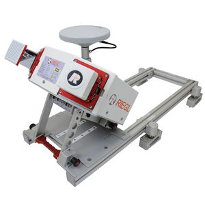
The new, fully integrated, accurate, and compact RIEGL VMZ Hybrid Mobile Laser Mapping System enables combined static and kinematic data acquisition using a single RIEGL VZ-400(i), VZ-1000 or VZ-2000(i) laser scanner – resulting in lower mobilization costs and a high return on investment.
Flexible setup, easy mounting, and a user-friendly workflow mobilize your RIEGL 3D Terrestrial Laser Scanner for applications like mapping of transportation infrastructure, city modeling, mine surveying, bulk measurements, etc.
Main Features
IMU/GNSS unit, fully integrated to support RIEGL VZ-400(i),VZ-1000 and VZ-2000(i) scanners for mobile (kinematic) data acquisition
Easy coupling and de-coupling of the VZ scanner from IMU/GNSS unit
Quick switch from mobile to terrestrial applications, and vice versa,without losing stability of system calibration
Flexible installation options - vertical and horizontal setup
Frame based roof-mount compatible with standard roof bars
Image data acquisition with a calibrated and GPS synchronized NIKON® DSLR camera
Additionally spherical camera systems such as FLIR Ladybug® are available
Single power supply for VZ scanner and IMU GNSS unit from a standard car battery
Easy system operation with single laptop running RiACQUIRE (additional camera may need an additional laptop)
Main Applications
Efficient Data and Image Acquisition
GIS Mapping and Asset Management
City Modeling
Surveying in Open-Pit Mining
Measurement of Bulk Materials
Road Surface Scans
Shore Surveying and Marine Applications
Civil Engineering
Topography
Monitoring
Facade Modeling
As-Built Surveying
Architecture
Archaeology
VIDEO
Catalogs
Related Searches
- Laser scanning system
- Measurement scanning system
- 3D scanning system
- Inspection scanning system
- High-resolution scanning system
- 2D scanning system
- High-precision scanning system
- High-speed scanning system
- Compact scanning system
- Portable scanning system
- LIDAR scanning system
- Fully integrated scanner
- Profile scanning system
- Rugged scanner
- Mobile scanning system
- Ethernet scanner
- Non-contact scanner
- Mapping scanning system
- Airborne scanning system
- Measuring scanning system
*Prices are pre-tax. They exclude delivery charges and customs duties and do not include additional charges for installation or activation options. Prices are indicative only and may vary by country, with changes to the cost of raw materials and exchange rates.


