- Metrology - Laboratory
- Metrology and Test Equipment
- 3D scanner
- SatLab Geosolutions AB
- Company
- Products
- Catalogs
- News & Trends
- Exhibitions
Laser scanning system SLS-13Dmeasurementmobile
Add to favorites
Compare this product
Characteristics
- Number of axes
- 3D
- Applications
- measurement
- Configuration
- mobile
Description
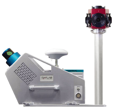
Satlab SLS is a Mobile Laser Scanning System solution using a fusion of sensors providing location, imagery and point cloud.
Satlab SLS is configurable by accommodating available high end sensors through a state of the art Sensor Fusion module which controls and synchronizes data streams from the sensors.
A tactical grade KVH 1750 IMU, ensures the highest accuracy in the harshest environmental conditions.
Satlab SL-650 laser sensor provides the best possible point cloud coverage. Spherical imagery is provided by the on board LadyBug 5 camera system.
Satlab SLS contains an embedded computer to log the data streams from all sensors together with time stamps thus ensuring no data can be lost during field operations due to cables or operator issues.
The integrated mounting structure makes it possible to use on any moving platform from off-road vehicles, to a train or small boat, to a personal car; all can easily be used as the scanning platform.
Catalogs
Related Searches
- Laser scanning system
- Measurement scanning system
- 3D scanning system
- High-precision scanning system
- Compact scanning system
- Precision level
- Portable scanning system
- Horizontal level
- LIDAR scanning system
- Fully integrated scanner
- Mobile scanning system
- Digital level
- Optical level
- Automatic level
- Hand-held scanner
- Mapping scanning system
- Scanner for mining applications
- Compact level
- Underground scanner
- RTK scanner
*Prices are pre-tax. They exclude delivery charges and customs duties and do not include additional charges for installation or activation options. Prices are indicative only and may vary by country, with changes to the cost of raw materials and exchange rates.


