- Metrology - Laboratory
- Inspection and Monitoring
- Bathymetric monitoring USV
- SatLab Geosolutions AB
- Company
- Products
- Catalogs
- News & Trends
- Exhibitions
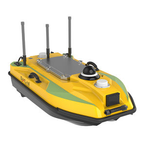
Autonomous USV HydroBoat 1200for hydrographic surveyingbathymetric monitoring

Add to favorites
Compare this product
Characteristics
- Type
- autonomous, for hydrographic surveying, bathymetric monitoring
Description
HydroBoat 1200—an embodiment of compactness and ease, tailored for seamless operation across a spectrum of equipment.
Enhanced by professional CFD technology, its stability finds new heights. Melded with high-precision single-beam echo sounder, GNSS directional positioning receiver, and an advanced intelligent boat-control system, it deftly serves varied water operational demands.
Augmented safety through embedded IMU, 360° pan-tilt camera, and millimeter-wave radar fortifies its attributes comprehensively. This autonomous vessel, which can be mounted with leading ADCP, side-scan sonar, dual-frequency sounder, multi-parameter water quality meter, image sonar, and more, stands poised as the quintessential partner for tasks encompassing current measurement, bathymetry, underwater survey, and water quality assessment.
1.Unmatched Versatility and Portability
A comprehensive platform that is designed especially for integrating with varied water measurement devices for hydrographic surveys and environmental monitoring. Its lightweight design and enhanced maneuverability facilitate operational flexibility in different instrument deployments and transportation for surveys between different sites.
2.Adaptive Water Flow
Precise hovering and efficient trajectory tracking. No fear of waves and wind. Follow predefined path with accuracy even in challenging envrionment.
3.New GNSS+IMU Combination Algorithm
Measure changes in velocity and orientation, and able to solve the accurate position information in GNSS-blocked areas to complete the planned work.
VIDEO
Catalogs
SatLab/USV/ HydroBoat 1200
4 Pages
Other SatLab Geosolutions AB products
Marine & Water Resources
Related Searches
- Environmental monitoring device
- Smart monitoring device
- High-precision monitoring device
- High-performance monitoring device
- Monitoring system for the construction industry
- Monitoring system for the petrochemical industry
- Monitoring system with visualization system
- Aquatic drone
- Monitoring USV
- Autonomous USV
- Bathymetric monitoring USV
- Environmental analysis monitoring device
- Hydrographic surveying USV
- Movement monitoring system
- Monitoring system for residential applications
*Prices are pre-tax. They exclude delivery charges and customs duties and do not include additional charges for installation or activation options. Prices are indicative only and may vary by country, with changes to the cost of raw materials and exchange rates.


