- Metrology - Laboratory
- Inspection and Monitoring
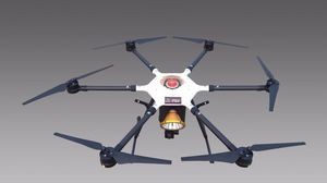
- Hexarotor UAV
- Shenzhen Qingzhun Technology Co., Ltd.

- Products
- Catalogs
- News & Trends
- Exhibitions
Hexarotor UAV QZU-04aerial photographymapping
Add to favorites
Compare this product
Characteristics
- Type
- hexarotor
- Applications
- aerial photography, mapping
- Endurance
30 min
- Payload
Min.: 0 kg
(0 lb)Max.: 15 kg
(33.069 lb)
Description
Shenzhen Qingzhun Technology Tilting 3D Modeling UAV adopts the most advanced design and manufacturing process in the world, can adapt to most weather and natural environment, highly modular body components; is a set of multi-rotor unmanned The tilting camera system is widely used in military, police, and other fields, and can provide users with faster and more intuitive 3D model data. The drone is especially dedicated to the development of military and police law enforcement agencies around the world. A practical and easy-to-use new tool with a more reliable execution system. At the same time, it is based on creating new products, improving user performance and ensuring fast, accurate and reliable data collection!
Features:
1. Automatically generate routes by selecting the aerial survey area;
2. Output a general-purpose PWM signal for aerial photography;
3. automatic route flight, but also can be switched to manual control;
4. High reliability, simple operation and use, low requirements for landing and landing;
5. The ground end monitors the flight status of the drone in real time;
6. built-in IOSD record drone flight information, easy to analyze the flight status of the drone;
7. The 3D model of the battlefield can be quickly established, and the 3D model can be used for urban planning, forest fire prevention, attack drills, etc., reducing inspection time and cost, and improving the enforceability of the planning scheme.
8. the camera group supports optical image stabilization, APS format, ISO 100-16000, can be used to shoot RAW photo format, providing more powerful space for post processing.
Other Shenzhen Qingzhun Technology Co., Ltd. products
Products
*Prices are pre-tax. They exclude delivery charges and customs duties and do not include additional charges for installation or activation options. Prices are indicative only and may vary by country, with changes to the cost of raw materials and exchange rates.


