
- Products
- Catalogs
- News & Trends
- Exhibitions
Quadrotor UAV Maverick Mappermappingautonomous

Add to favorites
Compare this product
Characteristics
- Type
- quadrotor
- Applications
- mapping
- Other characteristics
- autonomous
- Endurance
25 min
Description
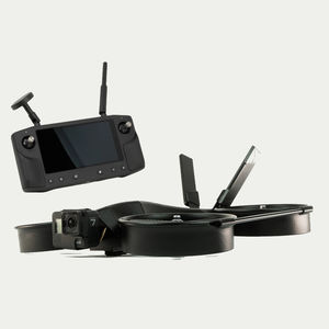
Introducing the Maverick Mapper. An efficient mapping drone that covers some ground! Autonomously map up to 40 acres in one 25 minute flight with the included Mapir Survey 3W camera on a 2-axis gimbal. The Mapper comes with a Skydroid controller that accepts any Android or iOS phone or tablet along with your favorite open-source ground station software.
Includes:
• - Skydroid Controller
• - MAPIR Survey 3 Camera
• - 2-Axis Gimbal
• - Battery
• - Battery Charger
• - Hard Case
Maverick Specs
• - Map up to 40 acres in one flight
• - 25 minutes endurance
• - 45 MPH - Top Speed
• - 30% quieter
• - Better efficiency up to 40% more flight time
• - Open source autonomy - Pixhawk Autopilot
• - Ducted Design
• - Safe by design - internal protection from rotating props.
• - Bump and Go
• - xPand Rail - accessory mount
• - Mount Options - MAPIR cameras, Spotlight, Loud Speaker, and more option with "Picatinny" rail.
• - Assembled in Idaho, USA
VIDEO
Related Searches
- Rotary wing UAV
- Monitoring drone
- Inspection drone
- Mapping drone
- Quadrotor drone
- Autonomous drone
- Drone for industrial applications
- Fixed-wing drone
- Gyro-stabilized turret
- Observation drone
- UAV gyro-stabilized turret
- Drone with thermal camera
- 2-axis gyro-stabilized turret
- Infrared camera UAV
- Instrument UAV
- Tethered drone
- UAV for the movie industry
*Prices are pre-tax. They exclude delivery charges and customs duties and do not include additional charges for installation or activation options. Prices are indicative only and may vary by country, with changes to the cost of raw materials and exchange rates.


