
- Products
- Catalogs
- News & Trends
- Exhibitions
Fixed-wing UAV X2Qmapping
Add to favorites
Compare this product
Characteristics
- Type
- fixed-wing
- Applications
- mapping
- Payload
250 g
(8.818 oz)
Description
Precision Mapping
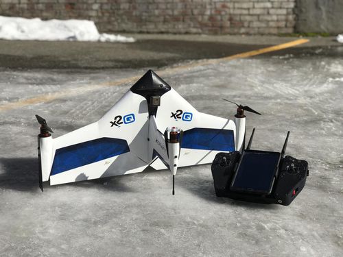
For high-definition geospatial mapping xCraft has created the x2Q. The multi-rotor fixed wing hybrid design enables the craft to perform vertical takeoff and landing (VTOL) as well as long endurance forward-flight with data telemetry radio link range of up to 30 km. The VTOL feature allows operations from a wider range of areas, while benefiting from longer-range fixed-wing flight. When transitioned to forward flight, the x2Q takes advantage of its fixed wing for more efficient flight increasing battery life and range beyond what is capable of similarly sized multi-rotor craft. The equipped Mapir Survey3 camera takes high-resolution geo-tagged images which can then be uploaded to the users preferred photogrammetry software and stitched into high definition 2D or 3D maps. To improve the user experience, real-time visualization during flight is available via an on-board HD camera. The ground control station (GCS) consists of a hand-held flight controller with integrated Android tablet for command and control. With replacement battery and 45 minute complete charge time users have the ability to fly multiple missions back to back. The complete x2Q kit comes with the following components: drone, controller, Android tablet, Mapir camera, HD camera, charger, 2 complete sets of propellers, 2 battery packs.
Fly With A Few Clicks
With our proprietary Android ground station, xCraft Mission Control, all flight planning, control, and monitoring functions are simple and intuitive. Operate solely from the included Android tablet for autonomous flights or from the included transmitter for more precise manual control.
Related Searches
- Rotary wing UAV
- Monitoring drone
- Quadrotor drone
- Inspection drone
- Mapping drone
- Autonomous drone
- Drone for industrial applications
- Gyro-stabilized turret
- Fixed-wing drone
- Observation drone
- UAV gyro-stabilized turret
- Drone with thermal camera
- 2-axis gyro-stabilized turret
- Infrared camera UAV
- Instrument UAV
- Tethered drone
- UAV for the movie industry
*Prices are pre-tax. They exclude delivery charges and customs duties and do not include additional charges for installation or activation options. Prices are indicative only and may vary by country, with changes to the cost of raw materials and exchange rates.


