- Metrology - Laboratory
- Metrology and Test Equipment
- 3D scanner
- Zoller + Fröhlich Laser Scanner

- Products
- Catalogs
- News & Trends
- Exhibitions
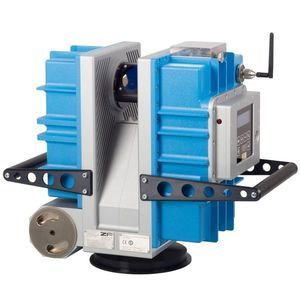
3D scanner IMAGER® 5016Ameasurementlasercompact
Add to favorites
Compare this product
Characteristics
- Number of axes
- 3D
- Applications
- measurement
- Technology
- laser
- Configuration
- compact, portable
- Other characteristics
- high-rate, high-precision, tilt
- Measuring distance
Min.: 30 cm
(11.8 in)Max.: 36,500 cm
(1,197.5 in)
Description
The terrestrial 3D laser scanner Z+F IMAGER® 5016A combines compact and lightweight design with state-of-the-art 3D laser scanning surveyor technology - allowing the user to reach new levels. It's equipped with an integrated HDR camera, internal lighting and positioning system. All components of the terrestrial 3D laser scanner have been further developed and adjusted to the new design, resulting in even better scanning results and a more efficient workflow. With feature A, which stands for Advanced, the 5016 receives twice as high scan rate of up to 2.187 million pixels/second and more options for leveling the scanner. If the dynamic compensator is deactivated or the tilt is outside the defined range, the tilt is detected by the IMU of the Z+F IMAGER® 5016A.
VERY HIGH SCAN RATE
The Z+F IMAGER® 5016A measures 2.187 million pixel / second.
OPTIMIZED LEVELING
The IMU integrated in the scanner enhanced leveling.
HIGH ACCURACY OF NAVIGATION
In the course of the IMU expansion, the accuracy of the scanner navigation itself has also been significantly improved and with it the accuracy of the automatic registration.
blue workflow®
Real-time registration on-site
Data and target verification
Multi-scanner support
IMU optimized leveling
Laser system
Laser class: 1
Beam diameter / divergence: ~ 3.5 mm @ 1m / ~ 0.3 mrad (1/e2, half angle)
Range resolution: 0.1 mm
Data acquisition rate: Max. 2.187 million pixel/sec.
Linearity error: ≤ 1 mm + 10 ppm/m
Range noise: 0.25 mm rms
Other Zoller + Fröhlich Laser Scanner products
3D laser scanner
Related Searches
- Laser scanning system
- Measurement scanning system
- 3D scanning system
- 2D scanning system
- High-speed scanning system
- High-precision scanning system
- Compact scanning system
- Portable scanning system
- Optical scanning system
- Fully integrated scanner
- Profile scanning system
- Color scanner
- Ethernet scanner
- Mapping scanning system
- Scanner for mining applications
- Underground scanner
- Cost-effective scanner
- Tilt scanner
*Prices are pre-tax. They exclude delivery charges and customs duties and do not include additional charges for installation or activation options. Prices are indicative only and may vary by country, with changes to the cost of raw materials and exchange rates.


